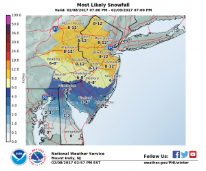
Officials in the Newtown area are preparing for a storm that is forecasted to dump between 6 inches to a foot of snow.
The National Weather Service on Wednesday evening said the storm would start late Wednesday night or early Thursday. The storm is predicted to start as rain before changing over to snow.
“There is high confidence in the precipitation occurring, but there remains some uncertainty with the timing for the transition from rain to sleet to snow, and thus snow amounts,” meteorologists at the government forecasting office said.
The heaviest snow is expected to move into Bucks County between 3 a.m. and noon. The snowfall rates could be as high as 2 inches per an hour before tapering off in the early afternoon.
“The snow should be wet in consistency and therefore will tend to stick to trees and power lines, possibly resulting in some power outages,” forecasters said.
In addition to the snow, there will be northerly winds of 15 to 30 MPH with some stronger gusts.
Bucks County was placed under a Winter Storm Warning in advance of the first flakes.
According to forecasters, snow-related road problems are expected to last into Thursday evening while below-freezing temperatures stick around.
Newtown Borough Council member Tara Grunde-McLaughlin advised residents Wednesday to remove cars from snow emergency routes in the municipality during the storm.
In addition to local public works crews and contractors, PennDOT officials will have crews in place to clear state roads of the snow.
The Council Rock School District had not made a decision on school for Thursday but Wednesday evening Superintendent Dr. Robert Fraser said during a committee meeting that all eyes are on the forecast. (UPDATE: The district is closed Thursday.)
The anticipated storm is predicted to be most impactful of the current winter season.


